详细说明
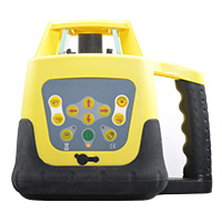
Product Name: Hv Full Function Rotating Laser Level Rotary Laser Level (FRE203) Model NO.: FRE203 Vertical Line: One Vertical Plane Horizontal Line: One Horizontal Plane Beam Color: Red Working Range: Min 400m (with Laser Detector) Remote Distance: Approximately 40m Indoor or 15m Outdoor Used for: MID-Ranged Distance Water Protection: IP55 Accuracy: H/V: 1mm in 10m Trademark: Fukuda Transport Package: Standard Export Carton Origin: China HS Code: 9015800090 Product Description HV Full Function Rotating Laser Rotary Laser Level (FRE203)FRE203HV is suitablefor major mid-ranged outdoor tasks,remodelingprojects and interiorceiling and installation.Specifications:1 Accuracy: Horiztontal: ±20″, Vertical:±20″ (1mm in 10m)2 Self-leveling range: ±5°3 Working range: Min 400m(with detector)4 Spinning speed: 60;120;300;600 r.p.m.5 Direction scanning:10°;45°;90°;180°6 Manual slope function:±10%, four directions7 Shocking alert function8 Remote distance: Approximately30m indoor / 10m outdoor,depending on operating position.9 Working temperature:-20ºC--+50ºC(-4.F--+122.F)10 Continious working :40 H,depending on operating condition11 Power: DC 4.8-- 6V(NI-MH rechargeable battery pack)12 Dimension: 222(L)X 171(W)X 226(h)mm13 Water-proof: IP5514 Standard Pack: LASER, Hard Carry Case, Radiation-proof Glass (Protection & Visibility Increase),and Magnetic LaserTargets, Remote Control, Both Alkaline and NIMH batterypacks, OperatingManual, Charger& Adaptor, and one laser detector with mount-holder (FRD100).Product: