详细说明
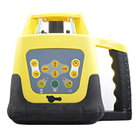
Product Name: Dgps Receiver Topographic Instrument Tilt Survey Sensor GPS Rtk (N70mini) Model NO.: Foif N70min Accuracy: Rtk H:8mm+1ppm RMS; Rtk V:15mm+1ppm RMS Main Board: Hemisphere P328 Internal Memory: 8GB Card Support: WiFi,Web Ui, Bluetooth,Electronic Bubble Handheld: A50 Water and Dust Proof: IP67 Trademark: Foif Transport Package: Standard Export Carton Specification: 148mm x 60mm Origin: Suzhou, Jiangsu, China HS Code: 9015800090 Product Description Dgps Receiver Topographic Instrument Tilt Survey Sensor GPS Rtk (N70)New generation receiver--- Compact, lightweight and handling! Work anywhere and anytime!Key features:1) Tilt Survey Sensorautomatic correct system by 30 degree2)Small size¢148mm*60mm, 0.85kg with battery3)4G LTE ModuleFits for various network4) High-capacity 48Wh non-removable battery,support USB charging5)Multi-constellation:GPS,BDS,GLONASS,Galileo,QZSSSpecifications:Product:Ourwarrantypolicy:1.Forinstruments(totalstation,theodolite,GNSS,autolevel),weoffer1yearwarranty. Foraccesories(Prism,pole,tripod,levellingstaff).weoffer6monthswarranty,fromthedayyougettheproduct.2.Forproductwithinthewarrantyperiod,pleasesendusphotostoshowtheproblem. Andthenwewill decidetosendyoupartsoryousendtheinstrumentbackto ustorepair. Wewillberesponsibleforthe double runfreightandothercost. Pleasemakesuretocontactusfirstinsteadofsendingthedamagedpartsdirectly tous.3. Forproblemoutofthewarrantyperiodorwarrantyliability,wewilljudgetheprobelmandquotedforyou. Youneedtopaydouble-runfreightandthemaintenacecost.4. Forallinstrumentweprovidelife-longtechnicalsupport. Remark:Improperuseof theinstrumentandman madedamageoftheinstrumentisnotcoverdinwarrantyliablity. Warranty onlyaimedattheproblemcausedbytheproductquality.