详细说明
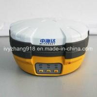
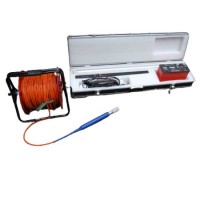
Product Name: New Hi-Target V30 Gnss Rtk GPS Land Survey Rtk GPS Model NO.: V30 GNSS RTK GPS Horizontal Line: -(2.5+1*10-6D)Mm~+(2.5+1*10-6D)Mm Vertical Lines: -(5+1*10-6D)Mm~+(5+1*10-6D)Mm Accuracy: 1mm Condition: New Satellite Signal: GPS, Glonass, Bds, Galileo, Sbas Channel: 220 Startup Time: 5s Rtk Horizontal Accuracy: 8mm+1ppm RMS Rtk Vertical Accuracy: 15mm+1ppm RMS Warrenty: 12 Months Waterproof/Dustproof: IP67 Weight: 38kg Trademark: Hi-Target Transport Package: Plastic Case Inside and Carton Box Outside Specification: CE, FCC Origin: China HS Code: 9105800090 Product Description New Hi-Target V30 GNSS RTKGPS Land Survey RTK GPSThe V30 GNSS RTK GPS system is designed to meet high quality standards at an affordable price. It is outstanding in its class, with a rugged design and user-friendly functions.*Technical parametersof the V30 Land Survey GNSS RTK GPS:>>Measurement• 220 Channels• Advanced Pacific Crest Maxwell 6 Custom Survey GNSS Technology• High precision multiple correlator for GNSS pseudo range measurements• Unfiltered, unsmoothed pseudo range measurements data for low noise, low multipath error, low time domain correlation and high dynamic response• Very low noise GNSS carrier phase measurements with <1 mm precision in a 1 Hz bandwidth• Signal-to-Noise ratios reported in dB-Hz• Proven Pacific Crest low elevation tracking technology>>Satellite signals tracked simultaneouslyGPS: Simultaneous L1C/A, L2C, L2E, L5GLONASS: Simultaneous L1C/A, L1P, L2C/A (GLonASS M only), L2PSBAS: Simultaneous L1 C/A, L5Galileo: Simultaneous L1 BOC, E5A, E5B, E5AltBOCBDS: B1, B2QZSS: L1 C/A, L1 SAIF, L2C, L5>>Positioning Performance*Static and Fast Static GNSS surveyingHorizontal: 2.5mm+0.5ppm RMSVertical: 5mm+0.5ppm RMS*Post Processing Kinematic1.(PPK / Stop & Go) GNSS surveyingHorizontal: 1cm+1ppm RMSVertical: 2.5cm+1ppm RMSInitialization time: typically 10 minutes for base while 5 minutes for roverInitialization reliability: typically > 99.9%2.RealtimeKinematic(RTK) surveyingHorizontal: 8mm+1ppm RMSVertical: 15mm+1ppm RMSInitialization time: typically < 8 secondsInitialization reliability: typically > 99.9%3.Code Differential GNSS positioningHorizontal: 25cm+1ppm RMSVertical: 50cm+1ppm RMSSBAS: 0.50m Horizontal, 0.85m Vertical*Main Applicationsof the V30 GNSS RTK GPS:Construction stakeoutRich point, line stakeout functions, combined with graphical user guidance to help you save more construction costTraffic PowerConvenient power direction finding, ranging, angle calculation function; comprehensive and practical road layout, the pile, pile edge measurement, vertical, cross-sectional measurementsCORS ApplicationCORS system for applications, just need one rover station can receive CORS RTK differential signal to do data collection, construction layout, etc.CORS stationHD-CORS combines the advantages of HI-TARGET, such as mature technology, stable running, long distance transmission, etc., it is the solution of choice for a city to build a continuous reference station.Control SurveyAn investment, multiple functions, V30 GNSS RTK dual frequency static measurement accuracy meets the requirements of any control measure, supporting mature professional data solver software that can help you complete a variety of high-precision control measurementsData collectionGIS-oriented system design hand book operating software, flexible encoding capabilities to meet your fast and efficient needs in data collection in the wildAbove Water MeasurementWork with HI-TARGET marine surveying, mapping software and echo sounder, easy to finish underwater topography measure, completely change the traditional mode of above water measurement and operationUnderwater Construction PositioningWith HI-TARGET marine construction positioning software, V30 GNSS RTK system could help you accurately complete riprap, arrangement, piling and other marine engineering, to meet the special requirements for marine engineering construction projects.*Contact US: