详细说明
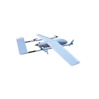
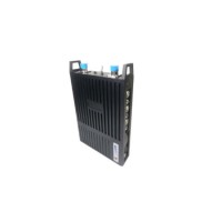
Product Name: HD Camera Video Transmitter Aerial Survey Mapping Drone Model NO.: CL-11 Structure: Fixed-Wing UAV Usage: Industrial, Military Size: Large Operating Radius: Remote Height: High Altitude Certification: ISO9001 Wingspan: 3.6m Length: 1.97m Conventional Payload: 3kg Max Takeoff Weighkg: 25g Max Flight Endurance: 2.0 Hrs with Mission Payload Cruising Speed: 105km/Hr Maximum Range: 200km with Mission Payload Ceiling(Asl): 3000m Takeoff/ Landing: Vertical Takeoff, Vertical Landing Trademark: Sagetown Transport Package: Flight Case Origin: China HS Code: 8802200011 Product Description Products Description VTOL Fixed-wing UAVThe Vertical take-off and landing fixed-wing UAV (VTOL drones for short hereinafter) have fewer requirements on landing field and airspace, could greatly improve the outfield operation efficiency of UAV.Feature of CL-11 Oil powered Fixed-wing VTOL UAV1.Oil powered. 2.Strong and durable.3.Usable in surveying and transportation, pipeline patrolling etc. 4.Vertically takingtoff and landing.5.2 hours flying with live video transmission up to 100Km.Specification of CL-11 DroneWingspan3.6mMax Range200km with missionpayloadLength1.97mFuel Tank Capacity 5LHeight0.7mCruising Speed 105km/hrConventionalpayload3kg(Fuel not included)Cruising speed100-120km/hMax Take-offWeight25kgMax FlightEndurance2.0 hrs with missionpayloadVTOL Propulsion4×electric BrushlessMotorsGas Engine 60cc two cylinderTotal Set-up Time <5minMax Speed 120km/hPortabilityEasy to transport, welladapted on siteMin Speed 75km/hVideo resolution1920*1080,50Km@Altitude notless than 200mCruising Altitude 100-1000mVideo transmissionLive video transferredto the groundCeiling (ASL) 3000 mTakeoff and LandingVertical takeoff and landingMission payloadRadio, Video and datatransmission, and onegimbals with RGB AND Infrared CameraWind load ratingwhen taking-off andlanding5 grade(11m/s)Wind Load Rating incruising6 grade(14m/s)Telemetry and remote control:Yes, should equipped with GCS, range not less than 50Km@Altitude not less than 200mRemark:CL-11 could take-off and land automatically, one key go home or vertically landingThe UAV platform includes airframe, power subsystem, autopilot, steering engine, and landing gear.Excluding sensors (e.g.gimbals, cameras, etc.) and data-links.UAV platform can do nothing except flying.While UAV system can carry out various tasks, such as surveillance, patrolling, transportation,communication relay, rescue search, reconnaissance, locking and tracking target in movement, etc.Details Image Sagetown series radio communication products developed by Beijing Sagetown Technology Co., Ltd. can transmit high-quality video streaming in metropolitan cities with tall buildings or at sea-level environment through multi-path effects (sea clutters). These products have excellent ability of "diffraction" and "penetrating" through buildings, urban areas, mountainous, sportsenvironment areas, etc.Application Field Product Package Certifications Company Profile Beijing Sagetown Technology Co ., Ltd. (Hereinafter called as Sagetown), established in 2003, is a national certified high-tech enterprise and engages in R & D and manufacture of UAV (Drone) and wireless digital communication system. With 17-year experience,Sagetown has become a leading provider in wireless datalink and industrial grade UAV.Sagetown has passed the Certification of Quality Management System in Research and Development of Armament ,the Registration Num is 16 QJ2 0484 R0S. This is to certify that the Quality Management System of Beijing Sagetown Technology Co ., Ltd. has met the requirements of the military quality management standard of China: GJB 9001B-2009.Recommend Products FAQ Q: Why do you choose Sagetown?A: We provide multi-domain services, Such as, surveillance drone for Chinese Academy of Sciences, UAV oil pipeline patrol project for PetroChina, a video and high-speed data transmission system for the SHENZHOU VI manned spacecraft return capsule , mobile command vehicle individual image acquisition system for 2008 Beijing Olympic Game etc.Q: What's your product range?A: We are engages in R & D and manufacture of UAV (Drone) and wireless digital communication system, It contains industrial and military grade.Q: Can you provide training?A: Of course,We can provide 3 days training for basic prictical operation for fixed-wing VTOL UAV. If you want more in-depth training, we can also support.Q: What does this price include?A: It is including fuselage, autopilot and IMS, one engine for flying, And The steering gear subsystem. Fuel tank and electricity power supply system, one set of battery, one handheld remote controller, one recharger, autopilot software on laptop, Support progamming flight. And can fly along pre-loaded GPS multi points. If you secelt VTOL fixed-wing drone, it's also includes four electricity powered engine for vertically takingoff and landing. Other configurations depend on requirements.